This research project addressed the topic of compass points in antiquity. Compass points or cardinal directions were far less standardized in Greek and Roman times than in the modern era.
Research
Although celestial bodies and winds belong all to the category of meteora, there was no need and thus no coherency in identifying astronomical directions, determined by the sun, stars or the zodiac, with wind directions. Ancient authors usually expressed indications of orientation in a relative frame of reference, depending on regional and local conditions, and only rarely in an absolute frame of reference like longitudinal and latitudinal coordinates. In addition to that, just like in the case of the different units of measurements, especially the stadium, information and hints on the standardization process between local, astral or wind orientations are hardly transmitted.
One consequence of a possible “overinterpretation” or “anachronistical reading” can often be found in modern translations of classical texts (of Hippocrates, Strabo, Ptolemy, etc.), where one regularly encounters the term “north” or “northerly” as translations of Boreas, Arktouros/Aparktias and Thraskios. However, the direction in question does not always correspond to “our” north (cf. e.g. Ptol. Geogr. 1.12, with Marinus of Tyre for Boreas): thus, for a more accurate understanding of such texts, a reconstruction of the process through which the information was registered and reused up to our source is essential. Such a study is all the more a desideratum for ancient wind roses, which vary from time to time and author to author; depending on the source which has transmitted them to us, these roses are far more complex in their elaboration and purpose than the four cardinal points we use in everyday life. They can be interpreted as paradigms of ancient “productions of space” – ranging from “higher” or “reasoned” geography of the likes of Ptolemy, to the “lower” or “intuitive” geography of daily life. This approach is based on the concept developed within research group (C-5), cf. Anca Dan, Wolfgang Crom, Klaus Geus, Günther Görz, Kurt Guckelsberger, Viola König, Thomas Poiss and Martin Thiering, “Common Sense Geography and Ancient Geographical Texts”, in: Space and Knowledge. Topoi Research Group Articles, eTopoi. Journal for Ancient Studies, Special Volume 6 (2016), 571–597
Results
1. Winds: perceptions and representations
This task involved taking stock of mentions of wind in Greek and Roman texts, with reference to understanding the importance of the winds for individual authors, time periods and regions. The general aim was to understand how winds were identified in different places, how empirical information was synthetized and associated with particular images and significations: in a word: how was a wind invented?
Anca Dan presented the partial results of her research on the Boreas (the northern wind par excellence) in the workshop “Zwischen Fiktion und Realität: Der Norden in der Literatur von der Antike bis zur Renaissance”organized by Klaus Geus, Gian Franco Chiai and Ekaterina Ilyushechkina.
2. Wind roses
This task involves analyzing the composition of several ancient wind roses, observing the sources, influences and possible transformation and translation processes (e.g. through acculturation) in their making.
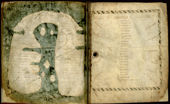
Albi Mappa Mundi, world map of the Merovingian period | Source: Albi, bibliothèque municipale, Ms. 29 (115)
Klaus Geus organized the reading group “Lektüregruppe Griechisch-römische Texte zur Geographie des Altertums” on Pseudo-Aristotle’s De mundo. An article taking into consideration the Eratosthenic background of the treatise’s geographical section, including the winds, is currently being prepared for print in collaboration with Anca Dan. Also, the research group which hosts the Key Topic Mapping discussed related research questions with Topoi fellows on many occasions, e.g. the use of winds in ancient navigation (Pascal Arnaud), or the winds in ancient cartographic and pictorial representations (Didier Marcotte).
Anca Dan presented results of her study on the Albi Mappa Mundi (8th century AD) and on the Indeculum quod maria vel venti sunt associated with it at the University of Paris I as well as in Albi, France:
Séminaire Mappa Mundi [PDF |520 KB]
À l’échelle du monde [PDF |432 KB]
The corrupted rose of 12 winds transmitted in the codex 29 of the Mediathèque in Albi, France, can be compared with Isidorus’ of Seville wind roses. Its mistakes reveal the sources and the aims in producing a wind rose in Late Antiquity and early Medieval times. A text and a multimedia publication are in preparation.